Air conditioning in Wotton-under-Edge
Yes. The town is a conservation area inside the Cotswolds National Landscape, with 193 list entries in a 2 km square around the Tolsey, and a 1993 Article 4 direction on named houses. That direction predates the heat pump right, but it does cover alterations to those houses, so we ask the council first. Stroud District Council decides, and we check your building before we quote.
At a glance
- Who decides
- Stroud District Council.
- Conservation area
- Wotton-under-Edge, Stroud District’s first: designated in 1972, extended in 1988.
- Article 4
- One direction, from 1993, on named houses: alterations, roofs, porches, satellite dishes, walls and painting.
193
entries on the National Heritage List in this 2 km square: 1 at Grade I, 4 at Grade II* and 188 at Grade II, among 2,673 buildings. One entry can cover a whole row.
A planned medieval town under the Cotswold edge, its streets laid out on burgage plots after a charter of 1253. Most streets are no wider than the buildings are tall.
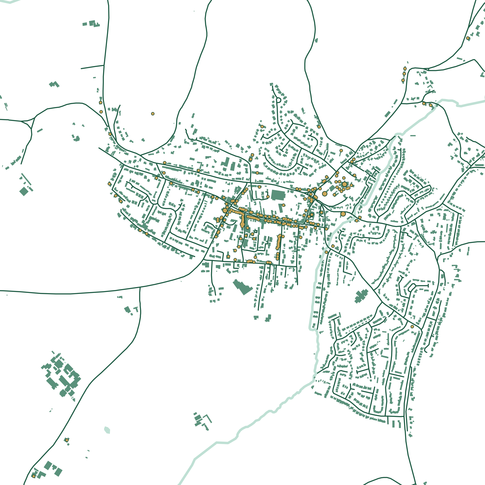
Press a number to find a building.
Late 13th-century arcades and a very fine six-stage 14th-century tower, mainly in Cotswold ashlar. List entry
16th century or earlier: rough render on a timber frame, part of it showing, under stone slate. List entry
Late medieval, remodelled in the 16th century: rendered limestone rubble with timber framing and a jettied gable. List entry
A 16th-century court house behind an 18th-century brick front, with a bell turret and a stone vaulted cellar. List entry
1638 and 1712: three wings round a courtyard, in exposed rubble under stone slate, with six gables to the street. List entry
Our count and drawing, 20 November 2026. Buildings, roads and water © OpenStreetMap contributors. Contains Historic England data © Historic England, Open Government Licence.
Render, frames and clay rag
The conservation area statement of 1999 calls render, lime-washed and later painted, the town’s one strong local tradition in walling, for two reasons. Many 16th and 17th-century buildings are timber-framed, with the frame hidden behind the render, and the local clay rag stone is soft, friable and weathers badly. Behind a rendered front there may be a frame, so we find out before anything is drilled.
Roofs are mixed: Cotswold stone slate on many, red clay double Roman tiles and pantiles from the Vale on others, and Welsh slate on the 19th-century terraces in Bradley Street and Old Town.
The Article 4 direction
The 1993 direction covers named houses across the town, from Bear Street and The Chipping to Long Street, Old Town and Valley Road. On those houses it removes the rights to enlarge, improve or otherwise alter the house, alter the roof, add a porch or a satellite dish, put up gates, fences or walls, and paint the outside. It doesn’t name heat pumps, which had no right of their own until 2011. But a unit fixed to one of those walls could count as an alteration, so we ask Stroud District Council first.
It isn’t in the government’s planning data, so a postcode check won’t show it. The council’s own page lists the addresses, and the statement says every building in the area was recorded when the direction was made.
If your house isn’t on the list and isn’t listed, the national right can apply: not on a wall or roof facing a road, and not nearer a road than the house. If it is listed, plan on listed building consent, inside as well as out. In October 2026 ministers said they were minded to replace Gloucestershire’s councils with a single one from April 2029. That isn’t final, and Stroud District Council decides until something changes.
Behind the frontages
Long Street and its neighbours present continuous fronts, with the long narrow plots behind used as gardens, yards and car parks, reached by alleys under the buildings. That’s usually where an outdoor unit belongs, and the alley is how it gets there.
In High Street, Long Street, Market Street and part of Church Street, people live above the shops. A flat in a building with a shop in it has no national right at all, because the right only covers houses and blocks that are wholly flats, so its outdoor unit needs a planning decision. The statement also asks that services such as satellite dishes, meter boxes and alarm boxes be carefully placed.
The Local Plan’s key employment sites in the town are Tabernacle Road and Renishaw at Old Town. More for businesses.
Your own building
Check it in three steps.
Almost everything above turns on two questions: is it listed, and is it in a conservation area? Both answers are public. Or leave it to us.
- 1
Is it listed?
Search Historic England’s National Heritage List by name or address. A listing covers the whole building, inside and out.
Search the List - 2
A conservation area, or an Article 4 direction?
The government’s planning data map shows both by postcode. It says its data may not yet be complete, so we check with the council as well.
- 3
Or leave it to us
We look both up before we quote, and tell you what they mean for where the unit can go.
See my price
How hot, how cold
We couldn’t find a long-term Met Office page for Wotton. These are from Filton, about 20 km away in the Vale. The statement says the scarp shelters the town from the colder winter winds, though we found no measurement of it.
- 21.7°
- average July high at Filton, 1991 to 2020
- 2.4°
- average January low at Filton
- 33
- air frost days a year at Filton
Questions
Asked in Wotton-under-Edge
Is my house covered by Wotton’s Article 4 direction?
Only if it’s one of the named houses on Stroud District Council’s list. The direction isn’t in the government’s planning data, so a postcode check won’t show it. We check the council’s list before we quote.
Can I have air conditioning in a flat above a shop?
Usually, but not under the national right, which only covers houses and blocks that are wholly flats. So the outdoor unit needs a planning application, and the yard behind is usually the place for it.
Is Wotton in the Cotswolds National Landscape?
Yes, completely. That doesn’t remove the heat pump right by itself. The conservation area, the Article 4 direction and any listing are what matter.
Sources
Buildings
Planning and the place
- Wotton-under-Edge Conservation Area Statement, November 1999
- Stroud District Council: Conservation Area no. 1, Wotton-under-Edge, and its Article 4 direction
- London Gazette notices for the conservation area, 1972 and 1988
- Stroud District Local Plan, November 2015
- Part 14, Class G, General Permitted Development Order 2015
- Government letter to Gloucestershire council leaders, 29 October 2026
Last checked 20 November 2026. This is a plain summary for people planning a job, not legal advice. Rules can apply differently to a specific address.